(PROVINCE) NATURE TRAIL IN THE TRIASSIC CHALKS
Between the Municipalities of Castelnuovo ne` Monti and Villaminozzo
provincia di Reggio Emilia
The Triassic Chalks area is located in the upper part of Val Secchia (Secchia Valley), in the bordering area between the Municipalities of Castelnuovo ne` Monti and Vallaminozzo. The area is of great naturalistic and landscape interest, since, thanks to the unique contours of the slopes and the particular qualities of the soil, relatively rare, or at least very localised species of animals and plants are found there. In this area, for example, we can find the rare Artemisia Lanata, a species of herb which has been adopted as the "symbol" of the whole area.
The nature trail winds through the different environments of the right-hand bank of the River Secchia, along its wide dry river bed: between striking rock faces and really beautiful scenery. The main naturalistic points of interest to be seen along the way are signposted and explained, thus creating a trail which encourages people to stop and observe these environmental phenomena at first hand.
WARNING
Visitors are invited to report missing signs or examples of lack respect for the environment to tel no. 0522 436685 (CAI Reggio Emilia) and 0522 811939 (CAI Castelnuovo ne` Monti) so that appropriate action can be taken as quickly as possible.
Guided tours can also be arranged via these numbers.
Tourist Area
The name of the protected area in the upper Val Secchia comes from the oldest rocks in the Reggio province: the "Triassic Chalks". This geological formation (also known as the "Anidriti di Burano") was formed more than 200 million years ago from the evaporation of sea water with a relatively high salt content. Thanks to the hot, dry climate, the evaporating phenomenon was not matched by precipitation, leading to the deposit of minerals dissolved in the water: first carbonates, then sulphates and finally halides. The presence of these particular rocks in the area, at a short distance, moreover, from the more famous "Pietra di Bismantova" (mountain), has puzzled the geological community: according to certain scholars, these rock forms arrived here from the other side of the Apennine ridge (Tuscany). Other geologists on the other hand, believe that the chalks are still rising from the depths of the subsoil among various types of rock; this happens due to its lower lithological weight, but it's most likely that both theories are in fact integrated. The first impression which strikes the observer is the apparent chaos in the chalk faces, often almost vertical above the river, which flows along their base. However, at times, stratum detritus or alluvial deposits covered in vegetation can be found at the foot of the slopes. The chalk peaks are mainly formed of chalks, anhydrides, limestones and dolomite limestones. With regards to the hydrology of these areas, it is important to point out the complete lack of surface water courses, except for the larger courses which run over alluvial material transported here over time. The independently flowing underground water systems, on the other hand, are well developed. Overall, the Chalks can be considered as huge reservoirs in which the flowing of underground water has produced the partial solubilization of these masses of rock. As a result, caves have been created in the subsoil and at the surface, which thanks to the karst phenomenon, develop into an underground environment.
On the other hand, in contrast to the similar phenomenon found in limestone areas, conditions within the natural caverns in the Triassic Chalks are not suitable for the formation of significant concretions such as stalactites and stalagmites; of caves and underground environments. On the opposite shore of the River Secchia, the Poiano springs are worth a mention; abundant salty-sulphate-alkaline springs, unique in its type in the entire region of Emilia Romagna.
The indicated Points of Naturalistic Interest
The Commission which protects the mountain area of Reggio (CAI) has created a series of information points placed along the nature trail, to enhance the visitor's appreciation of the environment as he goes along.
POINT 1 - Erratic Bismantova sandstone blocks
The Triassic Chalks area possesses another important landscape feature a short distance north, that is, the famous Pietra di Bismantova. Moreover, it can be reached on foot, heading off at the beginning of this nature trail, following the Bragazza brook, ascending the track which follows the course of the brook to the right. The large blocks of sandstone which we then encounter, at the beginning of the marked trail, show the erratic nature of the Bismantova blocks, which have broken off from the main block, rolling away from the "Pietra" and ending up in the neighbouring territory.
POINT 2 - Mulino di Vologno (Vologno Mill)
Power to move the millstones was provided by the canal passing by the mill. In fact water from the nearby Secchia was deviated to the mill. It was also accessed by a dug out road, linking the mill to the inhabited part of Vologno, situated further upriver. The inhabitants took this road every day by foot or on the backs of donkeys, to mill grain or other essential food products.
POINT 3 - Spring channel, rich in flora.
The water flowing along the Secchia's river bed runs between pebbly detritus masses, creating springs at the sides of the main course, like the one we can see here. The presence of water in these springs is dependent on how stony or gravely the underlying bed of the shore is. The vegetation present in these micro-environments is mainly composed of aquatic herbaceous plants and in particular: water plantain, watercress and veronica.
POINT 4 - Clearing with shrubs, possibly formerly cultivated
When a surface layer ceases to be influenced by human use, it is re-colonised by spontaneous vegetable species. The first plants to grow and develop are called pioneers. Their particular characteristic is that of being very hardy and able to adapt to hostile environments; as they develop in these difficult conditions they change the environment, modifying and gradually improving the substratum, permitting the arrival of ecologically more demanding species which would not have been able to survive in the original "Spartan" conditions.
POINT 5 - Meso-hygrophilous wood with poplars and alders
An example of a plant population which needs the constant presence of water; it can be classified half-way between a river-bed type and a true mesophyle (the xerophilous wood, on the other hand, is found in dry and arid environments). The small wood,which we now pass through, extends for about one kilometre, parallel to the river, and varies in width from a few metres to 150 metres. The water bed often comes to the surface and, with a network of rivulets, feeds a water-loving plant population, such as alders, willows and poplars. Maples, elms, hawthorns, crab grasses, cornels and dog rose bushes are found in the dryer areas, all mixed with chains of old man's beard, hops and honeysuckle, while hanging carex is frequently found in the moister parts.
POINT 6 - Isolated limestone crags, beaten by the river when in full flow.
Here we can see three limestone "crags" forming part of the river bed and which are lapped by water when the Secchia is full. On top of these crags, as far as 20 metres from the surface of the water, large drifted pebbles can be seen (transported here), indicating the ancient level of the river bed that the river possibly had many thousands of years ago (a similar situation is found with regards to the "Ca` Rabacchi" terrace).
POINT 7 - 8 - Mature wood with large Hawthorns
Here the plants are more mature, as can be seen from the superior height of the tree specimens and the more developed undergrowth. From the moment of its birth (germination), the plant is subjected to fierce natural selection which obliges it to compete with neighbouring plants in order to survive and reproduce. Those plants not able to win this battle to secure their own vital space die sooner or later. Here we can admire a wood which, though appearing similar to the previous wood, is less dependent on the dynamics of the river. The large hawthorns are worth pointing out, with a trunk diameter up to 20 centimetres. The hawthorn, besides having a difficult germination, rarely reaches diameters such as the ones here present. We almost always find it inserted in field boundary hedges or along roads in the form of shrubs and bushes. It is also recognisable in winter, for its characteristic red berries on its bare branches. The snowdrops, bluebells, crocuses and carexes are all beautiful in flower and brighten up this part of the itinerary.
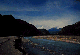
POINT 9 - 10 - Panoramic view of the Secchia
Two points which enjoy a beautiful view of the river course "cutting though" the Triassic Chalks and their white walls. Climbing northwards, leaving the marked route, you can reach inhabited Vologno in about 20 minutes.